|
|
|
All photographs are by the author unless stated otherwise. Click on thumbnails to view a larger version.
Reference has been made to A Guide to the Stone Circles of Britain, Ireland and Brittany by Aubrey Burl (1995) Y.U.P.
as well as Anne MacSween's a Wee Guide to Prehistoric Scotland(1999) Goblinshead
Numbers in brackets refer to OS map references.
|
|
 |
|
|
|
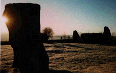
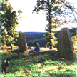
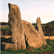
The massive recumbant and the flankers like two giant canine teeth! |
Again looking towards the recumbant and flankers. |
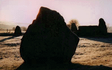
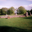
The pictures above are of the recumbant stone circle at Easter Aquorthies near Inverurie, taken on a chilly, frosty morning at the beginning of the year. This is my favourite circle, very beautiful, and it has, what I can only describe as, 'good vibes'. I'm not sure now, but I think that this was the first stone circle I visited. It has been restored and is under the care of the local authority and is well sign posted. The circle, comprised of nine stones graded in height from the flankers of 2.5m downwards has a diameter of around 18m. The people who erected these stones have paid attention to the colour as well as the height of the stones; half the circle is of grey granite and the other is made up of pale pinks. Could this be a representation of the phases of the moon? Recent studies have investigated the accoustics of this circle suggesting that the placing of the stones and shape create additional accoustic effects for ceremony enhancing the effect of drums played within the circle, for example.
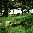
 From the circle looking towards
Bennachie and the Pictish hill-fort atop the Mither Tap.
Easter Aquorthies
circle ( NJ 244 005)
From the circle looking towards
Bennachie and the Pictish hill-fort atop the Mither Tap.
Easter Aquorthies
circle ( NJ 244 005)
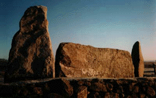
Aberdeenshire is well known for the great number of standing stone circles which date from the late Neolithic and Early Bronze Ages c.2700-2000 BC. These circles, known as recumbant circles from the prostrate stone ( lying flat on its side ) with tall upright stones ( flankers) on either side, as above at Aquorthies, which typify this regions variation. Aubrey Burl (1995) suggests that these recumbants were chosen and dressed so that they may be used to sight the moon rising and setting. Many of the recumbants remain in situ never having been moved and the chock-stones that were used to level the stone can still be seen, as at Midmar ( NJ 699 064) and Aikey Brae (NJ 959 471).
The Neolithic period was the time of the first farmers. Much of the woods and forests covering the land were felled and cleared during this period as land was required for growing crops and for grazing animals. In the North and on some of the Northern islands, such as Skara Brae on Orkney, where stone was used for building, several sites have survived very well and much can be gained from the interpretation of the remains. Here, further South where other materials such as timber and thatch were employed, traces of Neolithic settlements are much harder to detect. Many of these sites have been identified from 'cropmarks' viewed from the air. Holes dug for posts, pits, ditches and burials fall out of use, wood rots down and holes fill with soil leading to differing growing conditions for modern crops, after the land has been cleared and ploughed over the centuries. These differences in growth show up clearly at different times of the year and pinpoint an area for further study and excavation.
The Neolithic communities in Scotland buried their dead in communal tombs and cairns. Ceremony and ritual featured largely in the lives of the people from this period, some of the standing stones and circles as well as the tombs and cairns, being constructed of stone and by virtue of their size, have survived in various states and are much in evidence in this part of Scotland.
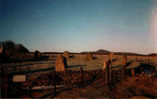
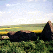
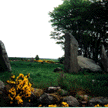
 Sunhoney (NJ 716 058)
I am sitting, sketching, on the recumbant, a huge thin slab of grey granite, which has fallen inwards. This stone has many groups of 'cupmarks'-small round indentations- engraved upon it. These marks have been identified as being 'astronomically situated' ie they are a graphical representation of the stars, or significant groups of stars or constellations. This ring is 25.4 metres in diameter and comprised of upright stones of red granite and gneiss. An excavation in the centre of the ring in the 19th century revealed deposits of cremated bones.The circle is situated on private farmland in a tree-circled patch. I found it to be a very pleasant and atmospheric place and well worth a visit, I'll be back!! Ask at the farm for permission, out of courtesy.
 Balquhain ( NJ 735
241)
Balquhain ( NJ 735
241)
Although this circle is much damaged with only four of the twelve stones standing, I like it a lot. It is situated in the middle of a field often in crop, I had to find a way through a crop of oil-seed rape over head height to reach it. Once there though it forms a wee tranquil green oasis in the middle of a sea of yellow buzzing with insects! Although fallen the stones remain in situ; the diameter is around 20m. The circle is comprised of a mixture stones found locally; quartzite, red granite and basalt. In keeping with other circles, the recumbant seems to have been of great importance and significance to the builders, and great care and effort appears to have been taken to obtain stones of imposing size and differing material and colour. Here the recumbant weighing over ten tons is made of a white-grained granite occurring some miles distant. There are cupmarks on the stones at this site, these occur on one of the flankers and on the stone adjacent to the opposite flanking stone. These cupmarks have been found to be astronomically significant also. Another stone, an 'outlier', not forming part of the circle, is a 3m tall pillar of quartz.
Visit my water colour page for another view of this circle with the Bennachie range forming a backdrop.
 Kirkton of Bourtie ( NJ 801
250 )
Kirkton of Bourtie ( NJ 801
250 )
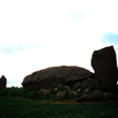
This circle has been very badly damaged with only the recumbant, one flanker and two other circle stones remaining in place. They are all of a local grey granite. Sited in a field quite near to the side of the road the massive recumbant is a very imposing sight. It is apparently the longest recumbant measuring 5.2m (17 feet) and weighing around thirty tons. It is not difficult to imagine the man-power required to manoever such an object and must have involved people from a large community or the co-operation and co-ordination of a group of communities joining together in a common and important purpose. The other stones of this circle are also large measuring some two metres (6 -71/2 feet) or so in height. The diameter of this ring may have been over 21.5 metres ( 71 ft). It is in a sorry state now, and I felt quite a sadness come over me when visiting, but it must have been quite an awsome spectacle in its completed state.
 Loanhead of Daviot ( NJ 747
288 )
Loanhead of Daviot ( NJ 747
288 ) 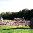
This circle is situated very near to where I used to live in Meikle Wartle, so I could visit it when ever I wanted to. Unfortunately I do not feel very comfortable at this place and do not choose to go there very often. I cannot explain these 'bad vibe' feelings any more than the very positive feelings experienced at Aquorthies. I have visited at different times of the year and in varying weather conditions but even on a lovely summer's day as above I still feel uneasy!? Anyway, this site is under state care and has been reconstructed. There has been extensive excavation of the site and of a later, early to middle Bronze Age cremation cemetery which lies next to it, where the remains of over 30 people and food-vessel urns were discovered.. The circle measures 20.7m in diameter and is dominated by a huge slab-like recumbant which has been split along it's length by frost. The interior of the ring appears cobbled with the remnants of a ring cairn leaving a central void of around 4.1m in diameter. The central cairn has been dated to around 4000 years ago and was therefore added some 1000 years after the circle was constructed. According to Burl an excavation of the central area in 1932 revealed that a fire of willow had burned there prior to the raising of the cairn and that there was much evidence of ritual and ceremonial placing of objects and bones in the central area and at bottom of the stones. There are cupmarks on one of the stones adjacent to a flanker, as at Balquhain, and Burl notes that, unusually for a North-eastern recumbant circle, a sightline from the centre of the circle passing these marks views a midwinter sunrise as opposed to the usual lunar observation. A major southern moonset is observed from the centre of the circle when looking past the western flanking stone.
 Dyce or Tyrebagger ( NJ 860
133)
Dyce or Tyrebagger ( NJ 860
133)
This one takes a bit of finding as the track leading up to it is through an industrial estate and a very tortuous route, however, it is well worth the trek. It is situated on the side of a hill, as they all tend to be, and looks across the industrial site across Aberdeen and out to sea. I especially was struck by the contrast and juxtaposition of the old and the new; helicopters taking off in the near distance flying off to take workers to the offshore installations! The stones are of a local red granite with the recumbant differing as usual, a darker shade of granite being chosen for this stone, a gigantic slab around 3.1m (10 feet) square. It has fallen but an impression of this imposing structure, 18.1m (59 feet) in diameter with standing stones measuring over 3 metres 911feet), can still be gained.
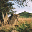 Dunnideer ( NJ 609 285)
Moving to the area of Aberdeenshire between the hills of Dunnideer and Hill o' Noth with their Pictish hill-forts has given me the opportunity to locate, visit and explore the places around here. There is much to found here, the whole area has been populated for many, many centuries and all have left their mark. Little remains of this circle, seen above with the hill of Dunnideer with it's very Glastonbury-like tower on the top in the background. The two flankers remain along with the recumbant which, as can be seen, has fallen and leaning inwards. The circle is very overgrown and not much can be seen, but it is quite an atmospheric place and I'll be back as I want to get some sketches for a painting of this place.
 Stonehead near Dunnideer
(NJ 601 288)
Stonehead near Dunnideer
(NJ 601 288)
These stones, the flankers and the massive recumbant are all that remain, some say all that ever were, of this ring. Although it can't be seen in this thumbnail, the larger image shows that the hill of Dunnideer with its hill-fort is very near to this circle and forms a backdrop along with the hill-fort on the Mither Tap of Bennachie. This stone is easily seen from the roadside in a field, along with some inquisitive ponies and goats.
We can offer Bed and Breakfast facilities for any one wishing coming to this area and are ideally placed for exploring and visiting the wealth of antiquities and sites of archaeological and historical interest here. Visit our B&B page for more info.
As I continue to visit, photograph and find out more about these sites I will update and add to this page. Meantime here are some links to other sites in the area that I have visited and like.
www, aberdeenshire.gov.uk/archaeology - This site is compiled by the archaeological service of Aberdeenshire Council, our local authority. It contains some aerial photography pictures of sites in this area in different weather and lighting conditions which show up beautifully some features which are difficult to see otherwise.
http://members.tripod.com/~megalithic - a map based index of megalithic images on the web.
http://easyweb.easynet.co.uk/~aburnham/stones.htm - a photo guide to prehistoric sites including some aerial images.
http://www.scran.ac.uk - SCRAN: Scottish Cultural Resources Access Network
|
|
|
|